

BANGOR-ON-DEE
Brief description of fishery:
We have four rods here every day of the week. This association has an excellent website at www.bodsaa.org.uk Many of the best spots are fishable from the bank. Take care as always when wading as there are sudden drop-offs and clay beds, but most runs are easy going on gravel. Club rule for brown trout – Fishing method is by fly only. All fish must be returned other than invasive species specified by NRW. Currently the club owns or leases more than 8 miles of water on the Welsh Dee, 1.5 miles of which is double-bank. All beats hold trout, grayling, sea trout and salmon. There are perch, pike and various coarse fish, even sea fish in the lower beats. There is good water on all beats for fly, spinner and bait. Beat 1 is the most popular and most accessible while the lower beats have much to offer with more space. Please note that the Sutton Green and Groves Farm beats are not available to our members. All club waters extend downstream from the New Bridge at Bangor-on-Dee.
The club has access to:
Bangor Village beat
Ormrods beat
Pickhill beat
Chicken Sheds beat
Rodens beat
Old Lower Hall beat
Dones Meadow beat
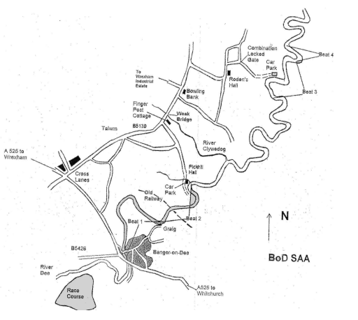
Beat maps and access directions are available from the BODSAA website, link above
Address
Bangor-on-Dee, Wrexham OS ref: SJ 388 454
Access & Parking
For Beats 1 & 2 the most direct route to Bangor is down the A483 from Chester past Wrexham and turn left onto the B5426. Follow this for several miles and through several crossroads until it meets the A525 at a tee junction. Turn right and take first left after the “New Bridge”. Turn left into the main street. The Royal Oak is on the right near the “Old Bridge” and you can use their car park. The pub lunch is recommended.
Beat 1, the Town Beat, is set in the beautiful village of Bangor-On-Dee with its ancient bridge. The fast flowing runs and deep gentle pools make this beat perfect for both Fly and Spinner and is the jewel in the BODSAA waters. The whole beat is easily accessible via a footpath running the full length and can indeed be fished in a loop starting in the village above the bridge and finishing down at Craig Island where a short walk back up Craig Lane will return you to the village and your car. While having a footpath along its length, the banks here are largely of clay and quite high so care should be taken when getting down to the river, especially in wet weather. Being of clay, some deep holes and cuts exist so care should be taken when wading. There are a number of pools with gravel bottom which are easily waded and identified on the map. The upper beat runs from the ‘New Bridge’ in Bangor-on-Dee and is predominately double-bank fishing down to the Graig Lane Cottages some 2 miles downstream of the New Bridge. There are many good holding spots for salmon and good runs for trout and grayling. The banks are easily accessible. A footpath runs the length of the right bank, with stiles or gates at all fences and hedge rows.
Pickhill
The second beat adjoins the first and runs for approximately 1 mile from the Graig Cottages downstream of Beat 1 and is left bank only. There is good fly water here for all game species. Parking is in a fenced-off car park down a lane past Pickhill Hall. See the map for route.
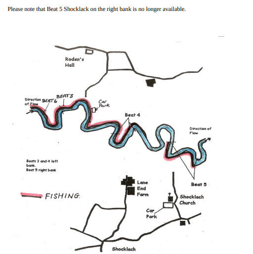
Rodens Hall, Done’s Meadow, Chicken Sheds, Rachel’s Meadow and Lower Hall. For these Beats from Bangor, turn right onto the A525 towards Wrexham. After a mile, at the traffic lights in Cross Lanes, turn right onto the B5130. Coming from the A483 you would take the A525 through Wrexham and turn left at the same lights onto the B5130. After over 2 miles pass a turning for Wrexham Industrial Estate on your left, and a couple of hundred yards further turn right. After half mile, the road sweeps to the left.Continue past Roden’s Hall farm for a quarter mile and take the first turning on your right. As the road bends 90 degrees left there is a gate on the right (there is a BoDSAA sign on the tree to the right of the gate). This gate has a combination lock with a button at the bottom. Continue down this track, through a second unlocked gate, and on for a further few hundred yards until you reach the car parking corals. The track can be difficult in wet weather. This parking provides access to the top end of these beats. These six Beats belonging to BoDSAA start 2 miles downstream of Beat 2 and form about 5 miles of continuous left bank fishing. There are many good salmon holding pools, particularly for spinning after June 1st.
Fishing is on the left bank only of the Dee. There is a small gap between Rachel’s Meadow and Lower Hall belonging to the private house there. The beats are not as popular or as picturesque as the town beats, but from the fishing point of view they are certainly equal to, if not better than them. They have an advantage in that the River Clywedog and the Worthenbury Brook join the Dee above this stretch, so when the water is low on the town beats it is often much higher here.
An indication of good water level is when the reading at Manley Weir is about 500. The banks are high and steep in most places and generally the waters are not easy to wade. Where wading is possible there is often a layer of silt which you sink into a few inches before hitting solid river bed. Anglers should be aware that there are a number of deep holes and drop-offs, so as with all wading, care should be taken, especially until you are
familiar with the waters.
There are plenty of coarse fish and good flat sea fish around for the days when salmon and trout are hard to catch. The banks here are quite open and easily accessible with good flow, even at summer levels. While all methods can fish well, these are good fly waters.
For parking use either of the two corals which protect vehicles from the cattle near
Roden’s Hall or on either side of the private house at Lower Hall following the
instructions below for that beat.
Some Good Spots Moving Downstream
The Captain’s Pool is at the top end of these beats.
Eel Cottage
This is a short stretch of deep water on the bend that quickly runs into the next pool. Please note that Beat 5 Shocklack on the right bank is no longer available.
The Boulders
There is a wall in the river running much of this stretch, through several turns. The fish lie on the outside of this wall, making it difficult to spin here. In the past, many fish have been taken from this water using shrimp and worm. At low water, the lower part of this pool can be waded and fished with a fly. Good grayling can be taken from the faster water.
The Channel
As the river straightens, the water shallows to 2-3 feet. This is good fly water all the way down to the big bend. The river bottom is of hard gravel here and is easily waded. Large shoals of sea-trout have been known to hold in this water. This is also good water for grayling and wild browns.
The Ferry Crossing Pool
The big pool on a big bend has recently been called Big Ben though was previously known as the Ferry Crossing, as there was an old ferry station here. This was used by people from Shocklach and Is-y-Coed. The anchor points for the ferry can still be seen. Occasional fish are taken from this pool, especially the tail which has a deep channel at its centre. The tail of the pool often holds good grayling which are free to rise though difficult to tempt. After the bend, the water narrows and quickens with broken water in mid stream.
The Car Park Pool
The start of this pool is a deep hole on a back eddy which then runs for a further 100 yards and often holds fish in low water. It has proven to be a good holding spot in recent years. Caution should be taken when fishing this spot due to the fast water and sudden drop off. After the run in, fish run hard to the far bank on this pool, making them difficult to cover. Fish avoid the backwash that exists on our bank. Beyond this pool, the water slows and deepens. Few fish are taken here.
Mile Deep
Towards the bend, the water shallows and quickens providing better fish holding water in the form of Mile Deep. Bank access is easy here. This water is 4-5 feet deep at normal levels, deepening at the bend. The fish lie close in on our bank on this stretch. The water then shallows again at the tail, with easy wading on a hard gravel bottom. This is easy fly water for all species, with trout and free rising grayling.
Shingles
The Shingles comes next on a horse shoe bend. As you round the bend, the water deepens from nothing to 4 feet on our bank and 7 feet on the far bank. Salmon lie at the fence line on the far bank. As the water straightens once more, there is an old groyne on the far bank. From just above the shingles through to the long straight can be very productive for grayling with a few trout. Many of the grayling here are large fish. Chub can often be encountered here, especially to the smaller spinners and spoons.
Phil’s Run
The water runs relatively steady and of a consistent depth for 200 yards below the old groyne. Half way down this stretch fish hold in the middle of the river.
At the next fence line is an old style. Below this is Phil’s Run. Just below the fence line, an island is starting to form. The occasional fish is taken here.
The island was taken out by the water board in the 40s and again in the 50s. Once more nature is repairing the damage. In the days of the island, this stretch was very productive. Hopefully those days will return with the return of the island.
Sand Pool
At the bottom of this straight is the Sand Pool which runs to the final bend on this beat with shallow water on the far bank, the inside of the bend, and deeper water on our bank. After the bend, the banks become steep and access is difficult and on occasion dangerous. This is shown looking downstream. Little fishing is done here.
Beat 4 Done’s Meadow
The water has the bottom of beat 3 as its top boundary, marked by the gate into the meadow from which it takes its name. Whilst only extending to a single meadow, this is on a horse-shoe and so provides approximately 500 yards of fishing. This water is left bank only and is on the inside of the bend.
The beat begins in the body of a pool with deep water close to the near bank under overhanging trees. The banks are steep here and access is difficult and on occasion dangerous. This stretch turns into a glide which narrows and quickens as the water pushes to the far bank as the river enters the bend and becomes a fast broken run punctuated by a small pool at its half way mark.
Following the run is a stretch of water containing 5 groynes on the far bank. Here, the water is shallower on our bank, with a deeper channel off the end of the groynes with deep back eddies between. At low water, salmon hold between the groynes, with fish moving to our bank at higher water as it becomes turbulent near the groynes.
After the bottom groyne, the water widens and slows at the final pool on the beat. Though the shortest of our beats, there is plenty of holding water which can accommodate several anglers. This water has a reputation for holding salmon at all times of the season and for producing fish at all heights. The water fishes well with the fly during lower water with best results to spinners in higher water. The lower end of these beats can also be accessed from Lower Hall, which now forms part of the Bangor waters.
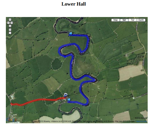
Lower Hall
The map shows the beat in blue and the lane to the parking in red. Parking is at the upper end of the beat.
For satnavs the postcode is LL13 9RT. The most straight-forward route from the Wirral is to pick up the A5130 at Chester. From Chester city follow directions to M53/A41 then A5130 to Farndon. Follow this through Aldford and Churton. To avoid Farndon town take the left fork after Churton and continue to the A534. Turn right onto the A534 for one mile until you take a left re-joining the A5130. After just fifty yards turn left onto a “B road”. Follow this, keeping straight, for 2.2 miles and arrive at Lower Hall (approx. 30 miles from West Kirby). The name is on a stone in the grass verge – not easy to spot.
About fifty yards further on is a track on the left leading to the river bank. At the end of the track is a private house in front of you and a barn to the left. Head for the barn, go through the metal gate and park on the concrete slab by the barn.
Display your club logo. The river is only twenty yards away. Please close all gates behind you. You can also follow the track to the right of the private house to access beats higher up the river.
The upper end of the beat starts here at the fence and is left bank only. Although there are only three fields as the crow flies, the river bank follows several large oxbows and bends.
Virtually the whole stretch of bank is open and the river easily accessible. The river bed is mainly sand or gravel with deep pools in places.
Apart from trout and salmon there is excellent coarse fishing here in winter. Being the closest of the beats to the sea, flat fish are often taken by deeply fished spinners.
Maps

Species
- Brown Trout
- Grayling
- Salmon
- Sea Trout